


Spain Topo Maps

Περιγραφή του Spain Topo Maps
+++ Νέο GPS Mapping App +++
Εύχρηστη εφαρμογή πλοήγησης GPS εξωτερικού / εξωτερικού με πρόσβαση στους καλύτερους τοπογραφικούς χάρτες και αεροφωτογραφίες για την Ισπανία.
Συμπεριλαμβανομένων των Βαλεαρίδων Νήσων και των Καναρίων Νήσων
++ Για offline χρήση, χρειάζονται τα χαρακτηριστικά PRO! ++
Γυρίστε το τηλέφωνο Andoid σας σε ένα υπαίθριο GPS για ταξίδια στην πίσω χώρα ΧΩΡΙΣ ΚΥΤΤΑΡΙΚΗ ΚΑΛΥΨΗ. Αυτή η εφαρμογή σας παρέχει παρόμοιες επιλογές χαρτογράφησης όπως ίσως γνωρίζετε από φορητές συσκευές GPS.
Συμπεριλαμβάνονται δωρεάν επίπεδα χαρτών:
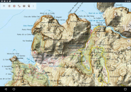
• Ισπανία Topo Χάρτης: Χάρτης Topográfico Nacional 1: 50.000 & 1: 25.000 (IGN MTN25 & MTN50)
• Χάρτης βάσης IGN: Βάση Topográfica Nacional 1: 25.000 (BTN25 & BCN25)
• Εικόνα Ισπανίας: Αεροφωτογραφίες υψηλής ανάλυσης. Σχέδιο Nacional de Ortofotografía Aérea (PNOA)
• Catalonia Topo Maps: Τοπογραφικοί χάρτες υψηλής ανάλυσης για την Καταλονία
• Χάρτης Κτηματολογίου: Cartografía Catastral
• OpenStreetMaps: Αυτοί οι χαρτογραφικοί χάρτες είναι μια πολύ χρήσιμη προσθήκη σε άλλα επίπεδα χαρτών. Περιέχει πολλά μοναδικά χαρακτηριστικά.
• OpenCycleMaps: Αυτοί οι χάρτες είναι ιδανικοί για να σχεδιάσετε ταξίδια ποδηλάτων
• ESRI Τοπογραφικό
• Αεροφωτογραφίες ESRI
• ESRI Street Map
• Google Road Map (μόνο online πρόσβαση)
• Δορυφορικές εικόνες Google (μόνο για online πρόσβαση)
• Google Terrain Map (μόνο online πρόσβαση)
• Bing Road Map (μόνο online πρόσβαση)
• Δορυφορικές εικόνες Bing (μόνο online πρόσβαση)
• Γη τη νύχτα
• Επικάλυψη Hillshading
Κύρια χαρακτηριστικά για υπαίθρια πλοήγηση:
• Δημιουργία και επεξεργασία σημείων αναφοράς
• GoTo-Waypoint-Πλοήγηση
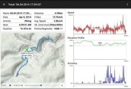
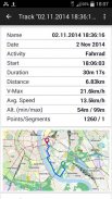
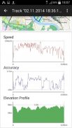
• Καταγραφή πορείας (με ταχύτητα, ανύψωση και προφίλ ακρίβειας)
• Tripmaster με πεδία για χιλιομετρητή, μέση ταχύτητα, ρουλεμάν, ανύψωση κλπ.
• Εξαγωγή GPX / KML / KMZ
• Αναζήτηση (placenames, POIs, streets)
• Προσαρμόσιμα πεδία δεδομένων στην προβολή χάρτη και στο Tripmaster (π.χ. ταχύτητα, απόσταση, πυξίδα, ...)
• Κοινή χρήση σημείων, διαδρομών ή διαδρομών (μέσω eMail, Whatsapp, Dropbox, Facebook, ..)
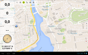
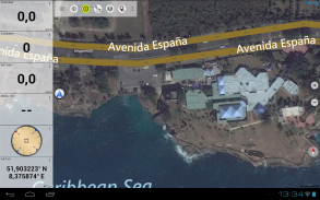
• Συντεταγμένες εμφάνισης σε Lat / Lon, UTM ή MGRS / USNG (Στρατιωτικό Πλέγμα / Εθνικό Δίκτυο ΗΠΑ)
• Καταγραφή και κοινή χρήση κομματιών με στατιστικά στοιχεία και προφίλ ανύψωσης
• Περιστροφή χάρτη (Track Up & North Up)
• Λάβετε την ανύψωση με μακρύ κλικ στο χάρτη
• Αναπαραγωγή παρακολούθησης
• και πολλά άλλα ...
Διαθέσιμες λειτουργίες Pro: (λειτουργίες Pro διαθέσιμες μέσω της Αγοράς εφαρμογών)
• Χρήση εκτός σύνδεσης - δεν απαιτείται κάλυψη κυττάρων
• Easy + Fast Bulk - λήψη πλακιδίων χαρτών για OFFLINE USAGE (όχι για τους χάρτες Google και Bing)
• Δημιουργία και επεξεργασία διαδρομών
• Πλοήγηση διαδρομής (Πλοήγηση από σημείο σε σημείο)
• Εισαγωγή GPX / KML / KMZ
• απεριόριστα σημεία και τραγούδια
• Προσθήκη άλλου διακομιστή πλακιδίων χαρτών
• Χωρίς διαφημίσεις
Χρήση εκτός σύνδεσης:
Όλα τα κελιά χαρτών που βλέπετε διατηρούνται σε προσωρινή μνήμη. Για να αποθηκεύσετε μεγάλες αποθηκευμένες περιοχές, πρέπει να αγοράσετε τις λειτουργίες Pro.
Χρησιμοποιήστε αυτήν την εφαρμογή πλοήγησης για υπαίθριες δραστηριότητες όπως πεζοπορία, ποδηλασία, κατασκήνωση, αναρρίχηση, ιππασία, σκι, κανό, κυνήγι, περιηγήσεις 4WD off-road ή έρευνα και διάσωση (SAR).
Προσθέστε προσαρμοσμένα σημεία διαδρομής σε μορφή γεωγραφικού μήκους / πλάτους, UTM ή MGRS / USNG με το σημείο WGS84.
Εισαγωγή / Εξαγωγή / Κοινοποίηση GPS-Σημείων / Τραγουδιών / Διαδρομών σε μορφή GPX ή KML KML / KMZ του Google Earth.
Προεγκαθιστάτε ΔΩΡΕΑΝ δεδομένα χάρτη για περιοχές χωρίς υπηρεσία κυττάρων (χαρακτηριστικό Pro!).
Σχόλια και αιτήματα χαρακτηριστικών στο spainmaps@atlogis.com
Ρίξτε μια ματιά στις άλλες εξωτερικές εφαρμογές πλοήγησης: https://play.google.com/store/search?q=atlogis
+++ ΔΕΝ παρακολουθούμε δραστηριότητες χρήστη ή συλλέγουμε δεδομένα χρήστη! +++
Spain Topo Maps - Έκδοση 7.7.0
(20-02-2025)
Spain Topo Maps - Πληροφορίες APK
Έκδοση APK: 7.7.0Πακέτο: com.atlogis.spainΤελευταία έκδοση του Spain Topo Maps
Άλλες εκδόσεις


Εφαρμογές στην ίδια κατηγορία

Μπορεί επίσης να σου αρέσουν...


